| Live Updates | Emergency Shelters | Flood Zones | How to Prepare |
This page is for general reference.
Live News Feed
Preparing Before, During, and After a Storm
- For Hurricane and Tropical Storm Preparedness: Be Hurricane Ready, brought to you by Hardware Hawaii
- National Weather Service Honolulu: Current Watches, Warnings, or Advisories for Hawaii (“updates every two or three minutes”)
- OAHU Department of Emergency Management: When a Hurricane Is Coming
When a Storm Is Headed Toward Hawaii
The National Weather Service issues watches and warnings for tropical cyclones.
-
- Watch: A Hurricane or Tropical Storm Watch is issued when a hurricane or tropical storm is expected within 48 hours. Use this time to prepare and review your family emergency plan and kit.
- Warning: A Hurricane or Tropical Storm Warning is issued when a hurricane or tropical storm is expected within 36 hours. Use this time to take protective actions to either evacuate or shelter-in-place. Stay tuned to local media for emergency information, including areas that should evacuate and when and where Hurricane Refuge Areas, or “shelters,” will open.
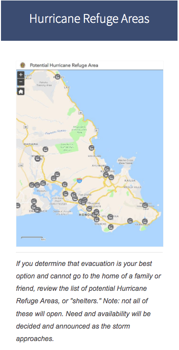
Emergency Shelters / Hurricane Refuge Areas (MAP)
OAHU Department of Emergency Management – Oahu’s Potential Hurricane Refuge Areas Map
*Not every refuge area on map will be open during an emergency. Depending on the circumstances, the City may use facilities other than those listed (in link). Specific locations and opening times will be determined based on the situation and will broadcast over local radio, TV, and official social media sites.
Use Your Emergency Plan
Make sure everyone in your household knows and understands your hurricane or severe weather plan. Also, have a plan for the office, kids’ daycare, and anywhere you frequent.
Hawaii Homeowners Handbook to Prepare for Natural Hazards, Fourth Edition
Staying Informed:
- Download the City and County of Honolulu’s smartphone app, HNL.info, which is also available as a website.
- Residents and visitors can track active storms by visiting the Central Pacific Hurricane Center.
Other resources:
Flood Zones
“Am I In A Flood Zone?”/Flood Hazard Assessment Tool map
The (above link) allows you to enter your physical address and uses scientific models to determine if your area is in an inundation or flood-prone zone.
Additional maps:
Where to Get Emergency Alerts
Emergency Alert System (EAS):
Important official emergency information such as evacuation notification and shelter locations will be broadcast over TV and radio stations statewide using the EAS.
Should your power go out during an emergency such as a hurricane, it then becomes vitally important that each household have a battery-operated radio and spare batteries on hand to receive emergency information. Newer hand-crank generators or solar-powered radios are also a good option.
EAS broadcasts for major coastal evacuations will be aired in conjunction with a three-minute sounding of all Outdoor Siren Warning Systems on O‘ahu.
Emergency and Community Information via Social Media/Online:
Honolulu Department of Emergency Management (HDEM)


Mayor Rick Blangiardi’s official accounts


Emergency Email and Text Message Alerts:
O‘ahu residents are encouraged to sign-up to receive emergency email, cellphone text messages and push alerts from the City and County of Honolulu by downloading the free HNL.info app from the App Store or Google Play.
You can also register online at HNL.info. Good for visitors, vacationers, and those returning to Oahu; standard text messaging rates may apply.
What to do to Prepare for a Storm
Preparing your home:
- Protect your property. Declutter drains and gutters. Consider hurricane shutters. Review insurance policies.
- Be prepared to bring loose, lightweight objects inside that could become projectiles in high winds (e.g., patio furniture, garbage cans); anchor objects that would be unsafe to bring inside (e.g., propane tanks); and trim or remove trees close enough to fall on the building.
- Be prepared to cover all of your home’s windows. Permanent storm shutters offer the best protection for windows. A second option is to board up windows with 5/8” exterior grade or marine plywood, cut to fit and ready to install.
Check insurance policies:
- Remember that homeowners insurance alone will not cover hurricane damage.
- You will need separate policies for hurricanes as well as flood insurance to protect against damage from coastal flooding.
- You can buy flood insurance separately through the National Flood Insurance Program. Always check and know what your existing insurance policies will or will not cover.
Non-English Speakers and Disabled:
If you have a family member who does not speak English or a family member who, due to a disability cannot receive emergency information readily, we highly recommend forming a core group of family or friends who can assist with translations or providing important emergency information as well as assisting with disaster preparedness actions and if needed, evacuation
Hurricanes and Tropical Storms:
Once a storm system crosses the 140-degree west longitude mark, it enters the Central Pacific area and would be in “Hawaiian” waters. Carefully monitor any hurricanes or tropical storms that develop or enter into Hawaiian waters until they safely pass our islands or dissipate.
Statewide Coverage
For information about different islands, refer to the links below.
Maui County Hawaii County Kauai CountyDownload the FEMA mobile app
Download the FEMA mobile app for disaster resources, weather alerts, and safety tips. Available in English and Spanish, the app provides a customizable checklist of emergency supplies, maps of open shelters and recovery centers, disaster survival tips, and weather alerts from the National Weather Service.
Visit Ready.gov for more tips. Disasters won’t wait. Neither should you.
Additional Links
*Reviewed/WIP: Aug 22, 2024


